[caption id="attachment_4118" align="alignright" width="300"]Wrecked vehicles and buildings in Roadtown, the capital of the British Virgin Islands, following Hurricane Irma. Wrecked vehicles and buildings in Roadtown, the capital of the British Virgin Islands, following Hurricane Irma.[/caption] In 16 years of Royal Air Force service, regular and reserve, I have served in Afghanistan, throughout the Middle East and at various spots in Africa and beyond. None of this prepared me for what I found when I deployed to the Caribbean on 8 September – at 12 hours’ notice – to support the UK’s massive humanitarian aid and disaster relief operation in the wake of Hurricane Irma. Irma – a violent, Category Five hurricane – cut a swathe through the region in early September and was followed within a fortnight by Hurricane Maria. Hard as I tried, my photography could scarcely capture the sense of loss and devastation the islands suffered. My deployment took me to countries throughout the Caribbean, where I had to help record the story and the relief effort. The British Virgin Islands (BVI) linger in my mind for many reasons. Hurricane Irma stripped BVI’s trees bare, tore rooves from sturdy houses and lobbed cars, cargo containers and aircraft around like Matchbox toys. This was formerly a place of rolling green hills and neat houses, turned into a traumatised wasteland painted in shades of brown and grey.

[caption id="attachment_3864" align="alignright" width="300"]Burifa Hill Gee Station An impressive background for a desolate shell[/caption] Often in travel photography unplanned diversions deliver some of the best opportunities to make photographs. While I was visiting Dunnet Head – the northernmost point in Great Britain – for a personal photography project, I stumbled upon a desolate piece of wartime history. It made for an absorbing opportunity to refine my black and white digital photography work, and to explore a little-known piece of Scottish history. This is the story of Burifa Hill Gee Station – and of the pictures I made there. Burifa Hill was an experimental radio station set up by the Air Ministry to guide Royal Air Force Bomber Command crews to targets in occupied Europe. Since German civil defence enforced blackouts, navigation was challenging. The Gee system helped aircrew to navigate by transmitting radio pulses from stations set across Great Britain: by comparing the pulse timings to a master station’s pulses, the aircrew could triangulate their positions. (The same kind of principle is at work today in GPS.) Using this system Bomber Command was able to launch raids into blacked-out occupied territory many hundreds of miles from the UK; in 1943 Burifa Hill itself was cited as having helped one crew launch a raid 620 miles from the base.

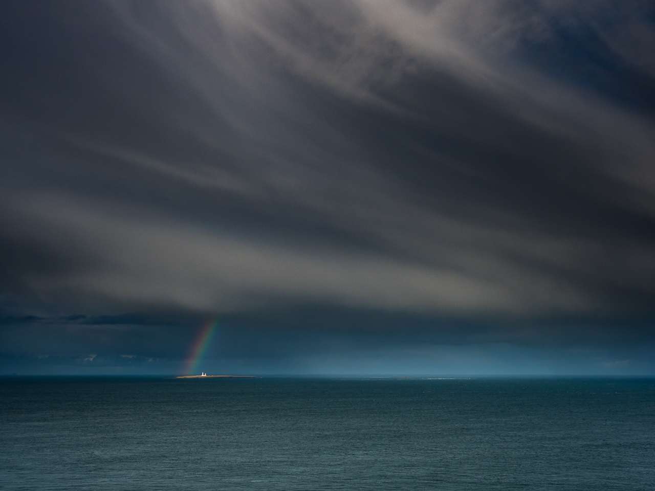
[caption id="attachment_3852" align="alignright" width="300"]Lowestoft Ness Lowestoft Ness on PAN-F in Rodinal 1+50[/caption] On Monday 22 May at 0810, I stepped on to a half-submerged concrete jetty in Lowestoft, Suffolk. Awash with seawater and slick with seaweed, this tiny walkway is the easternmost point in Great Britain – and journey’s end for my trip to the four extreme points of the mainland. I looked out to a glittering horizon beneath the blazing sun as my trusty OM-4Ti’s timer beeped behind me. At 0815 the shutter clicked, setting the seal on a personal project that has seen me travel nearly 2,200 miles by road, rail, foot and flight. Many of the pictures I’ve posted about this project so far have been digital, but my chosen medium for the actual project was film – specifically Ilford PAN F, a low-speed, fine-grain black and white film. 35mm film was the dominant photographic medium for much of the 20th Century, and most readers will remember having used it for holiday snaps at some point. For a film enthusiast, though, the attachment to the medium runs a little deeper than holiday snaps, and it involves quite a bit more thought.

[caption id="attachment_3766" align="alignright" width="225"]Rainbow seascape A rainbow frames Muckle Skerry Lighthouse in the Pentland Firth, near John o' Groats, Scotland.[/caption] The next stage in my personal photography project took me to the northernmost point on the British mainland: Dunnet Head, a storm-lashed promontory in the north of Scotland. For landscape photographers the whole place is a gift: one proud white lighthouse, plunging cliffs and a handful of fall-down wartime buildings (more to follow on those…). Standing at the head of the cliffs near the lighthouse you can watch squalls passing through the Pentland Firth, half-concealing the Orkneys on the horizon. If you and your camera are suitably weatherproof, you can wait for them to make landfall. I shoot with an Olympus OM-D E-M1 Mk II, which is more than capable of withstanding the elements - essential for making the most of passing storms. Stormy weather can seem soul-sapping at its worst, but it’s often worth hanging about to see what it can deliver. After visiting Dunnet Head I headed - via the wonderful Dunnet Bay Distillery - to Duncansby Head, the northwesternmost point of Great Britain (close to John o’ Groats). After a few hours of dull, watery light I noticed a storm blowing towards me, away from the sun and out to sea: perfect rainbow conditions. A quick sprint back to the lighthouse - fumbling a polariser on to my lens on the way - rewarded me with some truly magnificent views of rainbows drifting towards the horizon. These, I think, made every drop of rain worthwhile.

[caption id="attachment_3771" align="alignright" width="225"]Ardnamurchan scene Ardnamurchan Lighthouse seen from a nearby burn, Scotland.[/caption] At Corrachadh Mòr - the westernmost point on the British mainland - the wind is ceaseless. It tears at my jacket as I set up my tripod on ancient lava flows, frozen beneath pastel-blue skies and gilt-edged clouds. Before me, the Atlantic pounds the rocks and stretches out to a horizon marked, here and there, by the indistinct blur of distant squalls. When those squalls make landfall I shelter behind grey boulders, protecting my cameras from the stinging rain. From Corrachadh Mòr - an unmarked rocky hillock jutting into the sea - the distant Ardnamurchan Lighthouse and its access road are the sole signs of civilisation. More than anywhere else I’ve visited in Britain, this place feels like it’s at the edge of the world. It’s that remoteness that makes this visit so fundamental to my personal project, which will see me travel the length and breadth of Great Britain to photograph its four extreme points - northernmost, southernmost, easternmost and westernmost. Wilderness, remoteness and solitude have always been key motivators in my travel photography and street photography. Looking over my portfolio I can see two types of solitude: there’s the kind I feel when I’m alone in a crowd or urban space, and the kind I feel here at Corrachadh Mòr - where I’m at least two hours away from the nearest person. My personal project focuses squarely on the second kind of solitude. In each location I will make a self-portrait showing me alone in the landscape, as well as a picture of the landscape itself. I hope this will yield eight very different photographs, while still reflecting on the factors that unite those locations.

[caption id="attachment_3664" align="alignleft" width="300"]The extreme points of Great Britain The extreme points of Great Britain[/caption] 26 March sees the first shooting phase of my personal project, which will see me visit the four extreme points of mainland Great Britain - Dunnet Head in the North, Corrachadh Mór in the West, Lizard Point in the South and Lowestoft Ness in the East. It's a project about limits, solitude and the sea. At each location I'll make a series of pictures of the landscape, and of myself within the landscape. I hope the pictures will carry a sense of loneliness and awe in the face of the immensity of nature. As much as I'd love to tackle all four in a single long trip, common sense (and work!) demands I complete the journey in three phases. The first phase takes me to Cornwall to visit Lizard Point. There, as with the other locations, I'll be shooting primarily on medium format film on a Mamiya RB67. My film of choice is Delta 400, for its incredible tonality and sharpness. Just in case the MF option doesn't quite work out I'm also duplicating the series on 35mm PAN-F. If nothing else, this will give me a chance to learn more about printing PAN-F at a large scale. Time in the darkroom is never wasted.