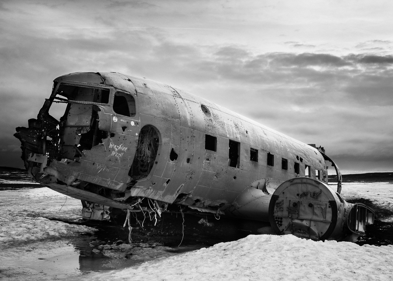
24 Feb The Iceland plane wreck – a selfie story
...

...

...
...
...
 The sun rises above Clayton Holt.[/caption]
When planning a travel photography job, preparation is important - especially for something as challenging as the Pennine Way, which I'll be tackling in April. I've spent more than enough time in mountains and on long-distance trails like the Annapurna Circuit and West Highland Way to know that nothing can be left to chance. That's especially the case where kit is concerned, and no less so for cameras than for boots, bivvy shelters and backpacks.
I've not had much of a chance to get hands-on with my camera - an Olympus OM-D E-M1 Mk II - so far this year, so I took the opportunity of a frosty Saturday morning to take it on a traipse through the South Downs National Park. My aim was as much to escape London as it was to re-engage my creativity.
The sun rises above Clayton Holt.[/caption]
When planning a travel photography job, preparation is important - especially for something as challenging as the Pennine Way, which I'll be tackling in April. I've spent more than enough time in mountains and on long-distance trails like the Annapurna Circuit and West Highland Way to know that nothing can be left to chance. That's especially the case where kit is concerned, and no less so for cameras than for boots, bivvy shelters and backpacks.
I've not had much of a chance to get hands-on with my camera - an Olympus OM-D E-M1 Mk II - so far this year, so I took the opportunity of a frosty Saturday morning to take it on a traipse through the South Downs National Park. My aim was as much to escape London as it was to re-engage my creativity.
 Wrecked vehicles and buildings in Roadtown, the capital of the British Virgin Islands, following Hurricane Irma.[/caption]
In 16 years of Royal Air Force service, regular and reserve, I have served in Afghanistan, throughout the Middle East and at various spots in Africa and beyond. None of this prepared me for what I found when I deployed to the Caribbean on 8 September – at 12 hours’ notice – to support the UK’s massive humanitarian aid and disaster relief operation in the wake of Hurricane Irma. Irma – a violent, Category Five hurricane – cut a swathe through the region in early September and was followed within a fortnight by Hurricane Maria. Hard as I tried, my photography could scarcely capture the sense of loss and devastation the islands suffered.
My deployment took me to countries throughout the Caribbean, where I had to help record the story and the relief effort. The British Virgin Islands (BVI) linger in my mind for many reasons. Hurricane Irma stripped BVI’s trees bare, tore rooves from sturdy houses and lobbed cars, cargo containers and aircraft around like Matchbox toys. This was formerly a place of rolling green hills and neat houses, turned into a traumatised wasteland painted in shades of brown and grey.
Wrecked vehicles and buildings in Roadtown, the capital of the British Virgin Islands, following Hurricane Irma.[/caption]
In 16 years of Royal Air Force service, regular and reserve, I have served in Afghanistan, throughout the Middle East and at various spots in Africa and beyond. None of this prepared me for what I found when I deployed to the Caribbean on 8 September – at 12 hours’ notice – to support the UK’s massive humanitarian aid and disaster relief operation in the wake of Hurricane Irma. Irma – a violent, Category Five hurricane – cut a swathe through the region in early September and was followed within a fortnight by Hurricane Maria. Hard as I tried, my photography could scarcely capture the sense of loss and devastation the islands suffered.
My deployment took me to countries throughout the Caribbean, where I had to help record the story and the relief effort. The British Virgin Islands (BVI) linger in my mind for many reasons. Hurricane Irma stripped BVI’s trees bare, tore rooves from sturdy houses and lobbed cars, cargo containers and aircraft around like Matchbox toys. This was formerly a place of rolling green hills and neat houses, turned into a traumatised wasteland painted in shades of brown and grey.
 An impressive background for a desolate shell[/caption]
Often in travel photography unplanned diversions deliver some of the best opportunities to make photographs. While I was visiting Dunnet Head – the northernmost point in Great Britain – for a personal photography project, I stumbled upon a desolate piece of wartime history. It made for an absorbing opportunity to refine my black and white digital photography work, and to explore a little-known piece of Scottish history. This is the story of Burifa Hill Gee Station – and of the pictures I made there.
Burifa Hill was an experimental radio station set up by the Air Ministry to guide Royal Air Force Bomber Command crews to targets in occupied Europe. Since German civil defence enforced blackouts, navigation was challenging. The Gee system helped aircrew to navigate by transmitting radio pulses from stations set across Great Britain: by comparing the pulse timings to a master station’s pulses, the aircrew could triangulate their positions. (The same kind of principle is at work today in GPS.) Using this system Bomber Command was able to launch raids into blacked-out occupied territory many hundreds of miles from the UK; in 1943 Burifa Hill itself was cited as having helped one crew launch a raid 620 miles from the base.
An impressive background for a desolate shell[/caption]
Often in travel photography unplanned diversions deliver some of the best opportunities to make photographs. While I was visiting Dunnet Head – the northernmost point in Great Britain – for a personal photography project, I stumbled upon a desolate piece of wartime history. It made for an absorbing opportunity to refine my black and white digital photography work, and to explore a little-known piece of Scottish history. This is the story of Burifa Hill Gee Station – and of the pictures I made there.
Burifa Hill was an experimental radio station set up by the Air Ministry to guide Royal Air Force Bomber Command crews to targets in occupied Europe. Since German civil defence enforced blackouts, navigation was challenging. The Gee system helped aircrew to navigate by transmitting radio pulses from stations set across Great Britain: by comparing the pulse timings to a master station’s pulses, the aircrew could triangulate their positions. (The same kind of principle is at work today in GPS.) Using this system Bomber Command was able to launch raids into blacked-out occupied territory many hundreds of miles from the UK; in 1943 Burifa Hill itself was cited as having helped one crew launch a raid 620 miles from the base.
 Cream tea at Lizard Point, Cornwall, England.[/caption]
Cornwall is one of those places I think I’ll never explore in full. I’m a frequent visitor, attracted to those wild coastlines, stormy skies and - let’s be honest - cream teas. So I was pleased to have a chance to visit a spot I’d not explored before, as part of my current personal photography project. I’m visiting the four extreme cardinal points of the UK, and the southernmost is Lizard Point.
I arrived at my camping spot (the marvellously indie Henry’s Campsite) late on a clear night and set up beneath sparkling skies. Night sky photography is a rare treat for a Londoner, but the basics are straightforward. The challenge is finding a worthy foreground subject. I hope my choice of the Lizard Lighthouse vindicates a windswept couple of hours in the teeth of a Cornish gale.
Cream tea at Lizard Point, Cornwall, England.[/caption]
Cornwall is one of those places I think I’ll never explore in full. I’m a frequent visitor, attracted to those wild coastlines, stormy skies and - let’s be honest - cream teas. So I was pleased to have a chance to visit a spot I’d not explored before, as part of my current personal photography project. I’m visiting the four extreme cardinal points of the UK, and the southernmost is Lizard Point.
I arrived at my camping spot (the marvellously indie Henry’s Campsite) late on a clear night and set up beneath sparkling skies. Night sky photography is a rare treat for a Londoner, but the basics are straightforward. The challenge is finding a worthy foreground subject. I hope my choice of the Lizard Lighthouse vindicates a windswept couple of hours in the teeth of a Cornish gale.